Zaitra Strom
Satellite-based forest quality mapping using Copernicus data.
Zaitra Strom is a data-driven environmental project focused on assessing forest quality and change using Copernicus satellite imagery. Building on our previous experience with green-tech, forestry quality, and land-use categorization projects, we designed and implemented an interactive analytical platform that translated complex satellite data into understandable, actionable insights.
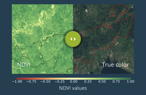
Our role covered the full technical stack, from research and data modeling to frontend architecture and deployment. We built an interactive web application with map-based visualization of raster and vector layers, NDVI analysis, Areas of Interest (AoI) selection, time-range comparison, and data panels with charts, tables, and image comparison sliders. The system allowed users to explore forest health trends over time, compare locations, and interpret satellite-derived indicators without needing specialist GIS knowledge.
The solution was designed as both a standalone web application and an integrable service layer, forming the foundation for further AI-driven prediction models and sustainability projects, including infrastructure protection and long-term environmental monitoring. If you’re looking to turn complex environmental or satellite data into actionable digital tools, let’s talk about how we can help your needs.
Impact & Value
By automating the collection and analysis of satellite data, Zaitra Strom dramatically reduced the cost and effort of forest monitoring compared to traditional ground surveys and aerial inspections. The platform delivers regular, predictable insights aligned with satellite flyovers, while also enabling historical analysis years into the past. This made it possible to detect changes in forest health, vegetation stress, and deforestation early – helping stakeholders react faster, plan interventions more effectively, and make data-driven decisions at a fraction of the usual cost.
Broader Context & Future Potential
Built as part of the Ström ecosystem, the project demonstrated how earth-observation technologies can be used not only for environmental protection but also for infrastructure safety and long-term sustainability. Automated algorithms evaluated forest vitality, tracked vegetation growth, and supported predictive models tailored to different geographic regions. The work contributed to Ström’s successful entry into the ESA incubator and laid the groundwork for future use cases such as power-line protection, AI-assisted risk prediction, and advanced environmental forecasting – showing how technology, when used responsibly, can actively help protect natural systems rather than harm them.
Vegetation near infrastructure
One of the major challenges lies in using satellite data and Earth observation imagery to analyze all problems associated with vegetation management. We work on regular, automated analyses that replace costly and time-consuming manual inspections.
High-voltage power lines
Energy and distribution companies must manage vegetation growth near their infrastructure, including high-voltage power lines running through forested areas. These corridors are exposed to multiple risks such as falling trees, branches growing too close to the lines and potentially causing wildfires, strong winds, and other environmental factors. Such threats can result in significant financial losses, environmental damage, and in extreme cases even pose a risk to human life.
Building on this challenge, data from the Zaitra Ström service enables energy and distribution companies to significantly accelerate and optimize vegetation management processes. By providing precise, up-to-date information on tree height, growth dynamics, species structure, and proximity to critical infrastructure, the service allows operators to identify high-risk areas early and prioritize interventions based on real risk rather than periodic manual inspections. This data-driven approach reduces the need for costly field surveys, shortens reaction times, supports predictive maintenance planning, and helps allocate resources more efficiently – ultimately lowering operational costs while improving safety, environmental protection, and regulatory compliance.